Data Compression for Numerical Raster Data
Introduction
This document describes the design, methods, and algorithms used by the Gridfour raster data compression implementation.
The Gridfour software project explores data compression techniques for numerical, grid-based data products. We are particularly interested in lossless compression for data sets that have an underlying spatial basis. There are many such data products that benefit from custom data compression. These include Digital Elevation Models (DEMs), geophysical and remote-sensing information, the S-100 marine hydrographic formats, meteorological analysis, laboratory observations, and other grid-based representations of natural phenomena.
The Gridfour API implements lossless data compression for both integer and floating-point raster data formats and supports on-the-fly decompression at runtime. The mechanisms that support authoring and reading raster data products can also serve as a convenient testbed for software developers who are investigating their own data-compression techniques. Developers can extend the capabilities of Gridfour by writing custom codec (coder-decoder) classes that are registered with the Gridfour API at runtime. This approach lets Gridfour's logic take care of data management tasks so that investigators can focus on their core algorithm development.
Techniques
An example raster data source: ETOPO1
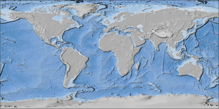
In the discussion that follows, we will use a data set called ETOPO1 to illustrate key points related to raster data compression. The ETOPO series (for Earth topography) is a family of global-scale elevation and ocean depth (bathymetry) data set developed by the U.S. National Oceanic and Atmospheric Administration (NOAA, 2026). ETOPO1 is a numeric raster that gives elevations in integer meters referenced to mean sea level, with negative values indicating depth. The raster has a spatial basis. Its grid is defined by latitude and longitude coordinates (Amante, 2009). Thus its grid cells are referenced to specific locations on the Earth. Figure 1 below shows a shaded-relief image that was created using data taken from ETOPO1.
We selected ETOPO1 as an example for a number of reasons. First, at 445 megabytes in size, it is large enough to be worth compressing. Also, the data is rich enough to be statistically interesting. And, finally, terrain data is something that is familiar that we should all have a good intuition for the way it behaves.
The following table summarizes the general properties for ETOPO1.
| Rows in raster | 10800 |
| Columns in raster | 21600 |
| Cells in raster | 233 million |
| Cell spacing | 1/60th degree |
| Cell size (at Equator) | 1.855 km (1.15 mi) |
| Min value (depth) | -10803 m |
| Max value (elevation) | 8333 m |
| Average value | -1818 m |
| Range of values | 19136 m |
| Storage format | two-byte integer |
| Storage size uncompressed | 445 megabytes |
| Storage size zip compressed | 246 megabytes |
| Storage size custom compressed | 100 megabytes |
| Shannon entropy | 12.9 bits/value |
Entropy in ETOPO1
The last entry in the ETOPO1 properties table gives a value for the Shannon entropy of the data source. Entropy, one of the fundamental ideas of information theory, was introduced by Claude Shannon (1948). For our purposes, we can use a loose definition of the term entropy to refer to the complexity of a data source. One of the ideas of the custom compression techniques we use in Gridfour is that we can apply transformations to reduce the complexity of our data sources. So the entropy calculation gives us a way of estimating how well those transformations work.
Entropy also gives us insight into the minimum size that a data compression scheme can attain. But there are a number of qualifying factors when applying that insight. For example, ETOPO1 features an entropy of 12.9 bits per value, but both the zip and custom compression achieve values lower than that (7.23 for zip, 3.60 for the custom compression).
For more information on this topic, see What Entropy tells us about Data Compression.
Standard data compression techniques
Data compression is a mature and extensively researched field of study. While there are numerous different data compression algorithms, two main techniques are widely used:
- Huffman coding
- Lempel-Ziv techniques (Zip applications, the Deflate API, etc.)
Huffman coding
Huffman coding is the oldest provably optimal data compression technique (Huffman, 1952). It assigns variable-length bit codes to each unique symbol in a text. The lengths of these bit codes are determined based on a frequency table that relates each symbol to the number of times it occurs in the source data set. Symbols (or values) that occur most frequently are assigned the shortest codes. Symbols that occur less frequently are assigned longer codes. Even though Huffman coding has been superseded by more recent techniques, it is still used as a core component of several compression formats including the JPEG image specification and the Deflate API.
Huffman coding is effective when a text contains a small set of unique symbols that occur with a significantly higher frequency than all other symbols combined.
Lempel-Ziv techniques (Deflate API)
While the Huffman code operates on individual symbols, Lempel-Ziv techniques are based on identifying sequences of symbols. Essentially, Lempel-Ziv techniques construct a dynamic dictionary of sequences from an arbitrary text and record bit sequences referring to entries from that dictionary. The Deflate API is based on a combination of the Lempel-Ziv 1977 variation and Huffman coding (Deutsch, 1996).
Lempel-Ziv techniques, and the Deflate API, are most effective when a text contains several sequences of symbols that occur multiple times.
Why do we need custom compression for raster data?
Data compression techniques are well established for conventional imagery and information products. So, at first glance, it may not be apparent why we would be interested in custom solutions for numerical raster formats. But, as Kidner and Smith pointed out, "most data and image compression algorithms fail to capitalize fully on the inherent redundancy in spatial data" (2003).
The limitations of conventional techniques when applied to spatial-based raster data are apparent in the compression results for ETOPO1. The Windows Zip utility reduces it from 445 megabytes down to 246, or 55 percent of its original size. But the same program reduces this HTML document to 31 percent of its size. Clearly, mainstream techniques work better on HTML or plain text than they do on numerical rasters.
Conventional techniques are limited in that they do not account for the numerical relationships between adjacent values in a spatial data set. But, as Kidner and Smith (1992), and others (Adobe 1992, Paeth 1991, etc.) showed, we can take advantage of these relationships to transform the data into a form that is more amenable to data compression. For example, Gridfour uses custom compression to reduce the size of ETOPO1 to 22 percent of its original size. And, because the compression is lossless, it faithfully preserves the original content.
How does spatially-aware compression reduce raster data size?
One of the seminal ideas of raster data compression is that there is often only a small variation in value from grid cell to grid cell. In many cases, it is possible for an algorithm to predict the value of a one grid cell based on those of its neighbors. A predicted value may not be always be a perfect match for the source data, but in general the difference between the true value and the prediction (i.e. the residual) should be small. Even better, the information content (the entropy) of the residuals is often much smaller than that of the source data.
The venerable TIFF image format implemented a differencing predictor. The differencing predictor exploits the fact that "many continuous-tone images rarely vary much in pixel value from one pixel to the next" (Adobe 1992, p. 64). It predicts that the value for each pixel will remain the same as its predecessor. The residuals are collected and passed to a conventional data compressor (LZW) which usually yields a substantial reduction in size. Kidner and Smith (1992) improved on this concept by using a triangle-based predictor which considered the values of three neighbors when estimating the value for a particular grid cell.
The Gridfour API implements both the differencing and triangle predictors. Details are given below. It also includes a more advanced algorithm based on Lagrange Multipliers that was proposed by Smith and Lewis in 1994.
Why ETOPO1 resists conventional data compression
Figure 2 below illustrates some of the factors that make ETOPO1 resistant to conventional data compression. At first glance, the prominent spike near elevation zero (the shoreline) might appear to be a natural for Huffman coding. Because Huffman assigns the shortest bit sequences to the most frequently occuring symbols in a text, a configuration which would be expected to reduce the compressed size of a data set. But even though the near-zero values occur more often than others across the range, they do not dominate the frequency table for encoded symbols. In fact, they represent less than five percent of the total number of grid cells in the raster. The cost of encoding the full range of values in the raster outweighs any saving that we might see for any particular subset of the distribution.
This situation reflects a trend that we often see in data sets such as ETOPO1. Raster products commonly have a broad set of unique values with similar frequencies of occurence. This characteristic drives up the Shannon entropy for the data set and leads toward less successful data compression. Additionally, most compression implementations carry a non-trivial overhead based on the number of unique symbols that occur in the source data. So the large range-of-values we see in many raster data products can have an even greater impact on the final size of a compressed data set.
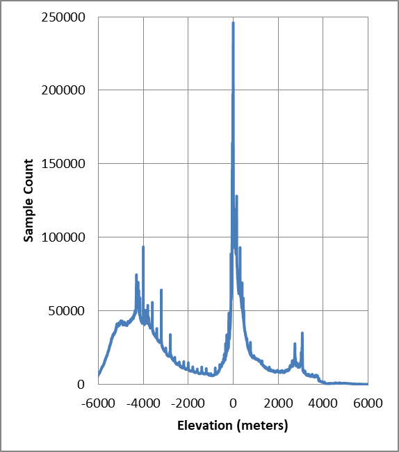
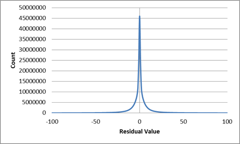
Figure 3 below shows what happens when we apply Kidner and Smith's triangle predictor techniques to ETOPO1. We obtain a set of residuals that are more amenable to data compression than the original values from the raster product. In the post-predictor results, the spike of near-zero residuals actually does dominate the frequency table. Furthermore, the range of unique residual values reduces to a smaller interval (-2970 to +1953). Finally, the overall entropy for the data set is reduced from 12.9 for the raw samples to 4.99 for the residuals. Later in these notes, we will consider ways of reducing that value even further.
Applying predictive techniques to raster data
Predictive techniques make a critical assumption about the nature of numerical raster data products with a spatial basis. They assume that the characteristics of two points closely located in space will tend to be similar. In other words, it assumes that the values of elements that are closely located spatially (i.e. in terms of grid coordinates) will also be close together numerically. And, thanks to this similarity (e.g. this tendency for neighboring samples to correlate), it is possible to use the values of one or more grid points to predict the value of a neighbor. This assumption is generally true in real-world examples such as elevation data. We expect that two points a few hundred meters apart are more likely to be similar than two points placed half way around the world. This idea of similarity based on proximity is sometimes referred to as "spatial autocorrelation" and has been extensively studied in Geographic Information Analysis and other fields.
A simple technique: the differencing predictor
The simplest predictor technique we apply to raster data is the differencing predictor. As mentioned above, the differencing predictor is used in a number of formats including the TIFF image specification. We implement the differencing technique using the following general outline:
- Define some sequence for specifying the values of the grid cells in the raster in order (row-major order, etc.).
- Reserve the first value of the first grid cell in the sequence as a "seed" value.
- For all other cells, predict that the value for the cell will be the same as its predecessor
- The difference of the actual value and the prediction is the residual. Record the residuals for all cells
- Pass the collection of residuals to a conventional data compression routine.
- The result will often be much smaller than a direct compression of the original values.
In Gridfour, the seed value is not included as part of the compression, but is treated as an overhead element.
For the most part, implementing a differencing predictor is straightforward. The one area of significant variation lies in how we define the traversal sequence for the grid cells in the raster. The selection of an ordering scheme affects the compression ratio for the output. The key assumption for the differencing technique is that the numerical values for adjacent cells are relatively close. So it is important that the traversal sequence preserves adjacency. Now consider the case in which an implementation traverses a grid in row-major order as it does in the TIFF standard. The process accesses grid cells one at a time across a row. Adjacency is preserved. But, at the end of a row, it jumps back to the first cell in the next row. For a large raster, that cell may be far removed in space from its predecessor.
There are patterns for traversing a raster that do preserve adjacency. The GRIB2 format includes a specification in which rows are traversed in alternating order (NCEP 2005, table 5.6). The first row is traversed left to right, the next right to left, etc. This zig-zag pattern preserves adjacency, but has a disadvantage in that the change in direction inverts the signs of the differences. Consider the case of a raster that has a trend of values slowly increasing from left to right. The left-to-right traversal will result in positive values. The right-to-left traversal will result in an equal number of negative values. But we've seen that data compression generally works better for a smaller set of unique symbols than for a larger set. Ideally, we prefer a grid-traversal pattern that preserves direction as consistently as possible.
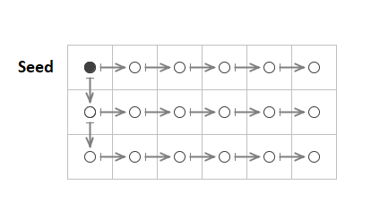
Figure 4 shows the pattern used in Gridfour's differencing predictor. The difference is always computed using an adjacent cell. But, at the transition from row to row, the computation uses the vertically adjacent cell rather than the horizontal.
It is worth repeating that the use of the differencing predictor for raster data is not unique to the Gridfour project. It is used in a number of specifications including the GRIB2 raster data format (NCEP 2005, table 5.6) and the TIFF image format (Adobe, 1992, p. 64, "Section 14: Differencing Predictor"). The PNG format includes a differencing predictor, but it treats subsequent grid rows as separate specifications rather than worrying about adjacency issues at the transition from row to row (World Wide Web Consortium, 2003, section 9 "Filtering").
More powerful techniques: the linear and triangle predictors
The standard version of Gridfour implements two additional predictor models: the linear predictor and the triangle predictor.
The linear predictor model predicts that the data varies as a linear function. The value for the next sample in a sequence is predicted using a straight-line computed from the two samples that preceded it. The predictor is applied on a row-by-row basis. The vertical coordinate of the points that precede the target point are assigned the values ZA, ZB respectively. If we assume that the grid points are spaced at equal intervals, then the predicted value, ZP, is given by ZP = 2 ✕ ZB - ZA.
The triangle predictor was described by Kidner & Smith (1992). It uses three neighboring points A, B, and C, to predict the value of a target sample as shown in the image below. The vertical coordinate of the points are assigned the values ZA, ZB, and ZC respectively. By treating the grid as having a fixed spacing between columns, s, and a fixed spacing between rows, t, the prediction computation is simplified to ZP = ZB + ZC -ZA.
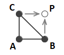
To see how this relationship is derived, start by taking each sample and the predicted point as vectors:
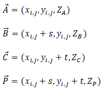
From linear algebra, we can compute the normal to a plane and locate a point P on that plane using the following:
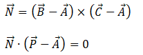
When we solve for ZP, the x, y, s, and t variables cancel out and we find the simple computation used by the triangle predictor model.
Both the linear and the triangle predictor require special handling to initialize the grid before applying the prediction computations. In the case of the linear predictor, Gridfour uses the seed value and the pattern established for the differencing predictor to pre-populate the first two columns of the grid. In the case of the triangle predictor, the first row and first column are populated using same approach. Once the grid is initialized, the specific predictors can be used for the remaining grid cells.
Serializing the residuals
Once the residuals are computed using a predictor-residual model, they are passed to compression processes based on conventional data compression algorithms such as the Huffman and Deflate APIs described above. One further challenge remains. Recall that when we processed ETOPO1 using the triangle predictor, it yielded residuals in the range -2970 to 1953. For other input data sets, the potential range of residuals can be much larger, up to and including the full range of signed integer types.
While the Gridfour implementation of canonical Huffman coding can accept integers as input, the Deflate API is designed to accept bytes. So in order to process residuals using Deflate, we need to marshal the residual values into the form of bytes.
It is feasible to simply split out the integer residual values into the component bytes, but doing so would tend to dilute the redundancy in the output data. Furthermore, a significant number of the residuals are quite small (using the triangle predictor, 87.9 percent of the residuals computed for ETOPO1 have an absolute value less than 15). So marshaling residuals to a 4-byte form would tend to fill the input into Deflate with a large number of superfluous zero-valued bytes.
To serialize the residuals for processing by Deflate, Gridfour uses a scheme that it calls the M32 code. M32 is an integer-to-byte coding scheme that adjusts the number of bytes in the output to reflect the magnitude of each term in the input. In that regard, it uses an approach similar to that used for the widely used UTF-8 character encoding. As in the case of UTF-8, the first byte in the sequence can represent either a literal value or a format-indicator that specifies the number of bytes to follow. M32 also resembles the variable-length integer code used by SQLite4 (SQLite4, 2019), except that it supports negative values as well as positive. The first byte in the output is essentially a hybrid value. For small-magnitude values ( in the range -126 to +126), it is just a signed-byte representation of the input value. The values -127 and +127 are used to introduce multi-byte sequences. And the value -128 is used to indicate the minimum 32-bit integer value, -2147483648, which Gridfour often uses as a null-data code. In the multi-byte sequences, the bytes that follow the introducer give bits for the numerical value in big-endian order. Each byte carries 7 bits of information with the high-order bit used to indicate if additional bytes follow. The length of the sequence depends on the magnitude of the residual to be coded. In the worst case, 6 bytes are required to encode a large magnitude residual (1 byte for the introducer, 5 bytes for the content).
The M32 coding scheme is effective in the case where the computed residuals tend to be small because it preserves the one-byte-per-value relationship. Again, in the case of larger residuals, the M32 code can actually be longer than the 4 bytes needed for a simple integer. Fortunately, a good predictor will usually produce small residuals. In fact, for the elevation data sets used when developing Gridfour, the average length of the M32 code sequences is about 1.013 bytes per grid value.
Tiling schemes and data compression
Although it may not seem an obvious part of a data compression scheme, there is one other consideration that can have a substantial influence on compression results: the way we choose to subdivide large rasters into smaller grids.
Many raster products are large enough that it is not feasible to process the entire data set all at once. Gridfour manages large rasters by subdividing the grid into a number of smaller, uniformly sized subgrids called tiles as shown in Figure 5 below.
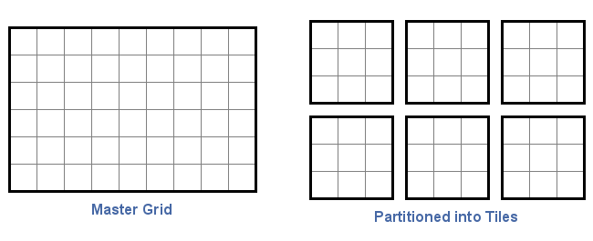
The Gridfour API implements logic that allows tiles to be compressed and decompressed independently. This approach is significant in terms of data compression because, in many data sets, the statistical properties of the data often varies across the domain of the data. For example, in the ETOPO1 elevation/bathymetry example, we would expect to see very different terrain (and very different data compression characteristics) over the Nullarbor Plain in Australia versus the steep drop offs along the Continental Shelf. Processing the raster as a single entity would combine data distributed across heterogenous areas. And, because compression depends on redundancy and uniformity, the extra complexity inherent in mixing together statistically different regions would lead to less successful results.
In spatial analysis, this tendency of the statistical properties of data to change across a data set is referred to as non-stationarity. A well-chosen tiling scheme allows an API to separate data into subsets that feature a self-consistent set of statistics. For example, it can significantly reduce the entropy (both pre and post prediction). In the case of ETOPO1, dividing the grid into 120x180 grid cell tiles yields an entropy of 9.39 bits/value averaged across all tiles compared to the 12.9 bits/value computed for the raster as a whole. Organizing the grid as tiles also allows the API to apply different predictors and different compression techniques depending on the local behavior of the data in each tile. Thus, the specification of tiles becomes an important consideration in applying data compression to a large raster.
Results using the standard compression codecs
The text below presents an analysis for the results of data compression using the standard Gridfour codecs (canonical Huffman and Deflate). The Gridfour API tests both codecs and predictors and chooses to use the combination that yields the smallest result. The canonical Huffman produces the smaller result in 44.6 percent of the cases, the Deflate predictor 55.4 percent. The entropy values are computed for the post-prediction results. Tiles that start with a high entropy before prediction usually yield somewhat higher entropy post-prediction. The triangle predictor is more powerful than the others. But when the source tile has low entropy, the predictors tend to be of approximately equal effectiveness. For low entropy cases, the less powerful predictors may be selected because they feature slightly less overhead than the triangle predictor.
GVRS Canonical Huffman                        Compressed Output    |     Predictor Residuals
  Predictor                Times Used       bits/sym    bits/tile  |  esc-bits    avg-unique  entropy | code table
   Differencing              172 ( 1.6 %)     1.83       39426.2   |      0.2        21.7      1.69   |  173.9
   Linear                   1190 (11.0 %)     3.20       69093.4   |     33.8       106.1      3.12   |  535.8
   Triangle                 3452 (32.0 %)     4.65      100336.0   |    441.9       145.7      4.51   |  539.5
   All Predictors           4814 (44.6 %)     4.19       90436.7   |    325.2       131.5      4.06   |  525.5

Gridfour_Deflate                              Compressed Output    |      Predictor Residuals
  Predictor                Times Used       bits/sym    bits/tile  | m32 avg-len   avg-unique  entropy
   Differencing              713 ( 6.6 %)     1.26       27227.3   |   21601.0        21.4      1.18
   Linear                    502 ( 4.6 %)     2.52       54411.7   |   21641.7        95.4      2.60
   Triangle                 4771 (44.2 %)     5.22      112724.1   |   21752.8       183.7      5.34
   All Predictors           5986 (55.4 %)     4.52       97650.2   |   21725.4       156.9      4.61
Optimal predictors using Lagrange multipliers
The Gridfour API features an additional predictor that is based on the method of Lagrange multipliers. The predictor extends the number of neighboring grid cells that are used in a prediction to 12. It estimates a value based on a linear combination of the neighbor values. Coefficients for the weighted sum are selected for each tile using a Lagrange multiplier solution. The result is a highly effective data compression scheme.
The Lagrange Multiplier technique is essentially a multi-variable linear regression with the added constraint that the average residual is zero. The algorithm was first described by Lewis & Smith (1993). Details for the Gridfour implementation are provided in a separate article at Lossless Compression for Raster Data using Optimal Predictors.
The optimal predictor achieves the best compression ratios of any solution currently implemented by Gridfour. But that performance comes at the cost of extra processing time for both compression and decompression. So it is treated as an optional selection in the Gridfour API. Table 2 below gives compression and decompression statistics for different codec and predictor configurations when processing the ETOPO1 data set. Tests were performed using the Gridfour Java API running on a medium-scale laptop computer running Windows.
| Codec/Predictor | Storage size | Compress (seconds) |
Decompress (seconds) |
|---|---|---|---|
| Huffman | 125.26 MB | 23.9 | 1.9 |
| Huffman & Deflate | 121.91 MB | 64.7 | 2.0 |
| Huffman, Deflate, Optimal Predictors | 100.32 MB | 114.1 | 5.1 |
Compression for rasters with floating-point formats
Raster data sets that feature non-integral floating-point values present different challenges than the integer formats described above. Rasters that feature floating-point data tend to have a higher degree of entropy than integer-based formats. And the prediction techniques that work well for integer data are usually not effective for floating-point formats. When a predictor operates over a floating-point raster, the residuals may be of a lower magnitude than the source values, but that does not reduce the complexity of the mantissas. The low-order bits simply propagate across computations.
A four-byte floating point format has three distinct components: the sign bit, the exponent (8 bits), and the mantissa (23 bits). Often, the components have different degrees of entropy. For example, consider a raster consisting of all positive values hovering near 1.0. The sign bit is always the same and will have an entropy of zero. The exponent byte will have the same, or nearly the same values. So it will also compress effectively. But the mantissa will tend to have quite a bit of entropy, especially in the case of a random or nearly random variable. So the current Gridfour implementation takes the approach of treating the component elements of its source data as separate data sets and passing them to conventional compressors.
Details about the Gridfour approach to compressing floating-point rasters are provided at Lossless Compression for Floating Point Data. The Gridfour project is interested in investigating alternative (potentially better) techniques.
The ETOPO-2022 floating-point raster data set
In 2022, NOAA released an updated version of their ETOPO data products that used floating point values rather than integers. The data set includes products at different resolutions, including a 1-minute-of-arc product equivalent to ETOPO1. That file is 890 megabytes and has an overall entropy of 21.1 bits/value. Gridfour compresses the data to 417 megabytes, or about 47 percent of its original size. While this is an slight improvement over the source NetCDF format (456 megabytes), it is not particularly satisfying. The text below shows summary information from the compression results. The high-order 7 bits of the mantissa (the row labeled Mantissa-1) have a lower entropy than the middle and lower bytes (Mantissa-2 and Mantissa-3). The Input column indicates the number of bytes before compression, the Compressed column indicates the resulting compression:
Gridfour_Float
     Element             Input      Compressed     (Reduction)    Entropy   Bits/Symbol
     Sign bits            2700          68.64       ( 2.5422%)      0.18     0.03
     Exponent            21600         830.03       ( 3.8427%)      0.93     0.31
     Mantissa-1 delta    18900        9194.47       (48.6480%)      3.32     3.41
     Mantissa-2 delta    21600       19813.16       (91.7276%)      7.37     7.34
     Mantissa-3 delta    21600       10546.48       (48.8263%)      3.99     3.91

   Average Bytes/Tile        40474.79        (46.8458%)
   Average Bytes/Sample          1.87        (46.8458%)
   Average Bits/Sample          14.99
Conclusion
The introduction to this article made the claim that the Gridfour package is intended to serve as a testbed for investigators and software developers who wish to experiment with their own solutions for raster data compression. We hope that by describing the current implementations, we demonstrated some of the reasons that we think that claim is valid.
There are many promising avenues to explore for better solutions to the raster data compression problem. Kidner and Smith (2003) used a more powerful predictor based on Lagrange multipliers and arithmetic coding. The Gridfour implementation of this feature is covered in our project notes Lossless Compression for Raster Data using Optimal Predictors. Some commercial and public solutions, including the JPEG 2000 standard, use wavelet functions. Data compression continues to be an area of active interest in the software community, and we fully expect that new techniques are waiting to be discovered.
The Gridfour project is especially interested in lossless, or nearly lossless, techniques for compressing real-valued data. The current Gridfour implementation implements compression for floating point data, but the results are not as successful as they are for integers. We would like to investigate further solutions for floating-point formats.
If you are investigating raster-based data compression, we wish you the best of luck and hope that insights from Gridfour can help you on your way. And, as always, we welcome your ideas and suggestions.
References
Adobe Systems, Inc. (1992). TIFF Revision 6.0 Final – June 3, 1992. Retrieved from https://download.osgeo.org/libtiff/doc/TIFF6.pdf
Amante, C. and B. W. Eakins (2009). ETOPO1 1 Arc-Minute Global Relief Model: Procedures, Data Sources and Analysis. NOAA Technical Memorandum NESDIS NGDC-24, DOI: 10.7289/V5C8276M
Cutler, C. Chapin. (1950). U.S. Patent No. 2605361, Differential Quantization of Communication Signals. Filed June 29, 1950, issued July 29, 1952
Deutsch, L. Peter (1996). DEFLATE Compressed Data Format Specification version 1.3. IETF. p. 1. sec. Abstract. doi:10.17487/RFC1951. RFC 1951.
Huffman, D. (1952). A Method for the Construction of Minimum-Redundancy Codes (PDF). Proceedings of the IRE. 40 (9): 1098–1101. doi:10.1109/JRPROC.1952.273898.
Kidner, D.B. and Smith, D.H. (1992). Compression of digital elevation models by Huffman coding. Computers and Geosciences, 18(8), 1013-1034.
Kidner, D.B. & Smith, D.H. (2003). Advances in data compression of digital elevation models. Computers & Geosciences 29 (8), 985-1002.
Lewis, M., &; Smith, D.H. (1993). Optimal predictors for the data compression of digital elevation models using the method of Lagrange multipliers. In Auto-Carto XI Proceedings of the International Symposium on Computer-Assisted Cartography, Oct 30-Nov 1, 1993. PDF document accessed August, 2026 from https://cartogis.org/docs/proceedings/archive/auto-carto-11/pdf/optimal-predictors-for-the-data-compression-of-digital-elevation-models-using-the-method-of-lagrange-multipliers.pdf
National Oceanic and Atmospheric Administration [NOAA], 2026. ETOPO Global Relief Model. National Centers for Environmental Information website accessed September 2026 from https://www.ncei.noaa.gov/products/etopo-global-relief-model
National Weather Service -- National Centers for Environmental Prediction [NCEP], 2005. NCEP WMO GRIB2 Documentation. Accessed January 2020 from https://www.nco.ncep.noaa.gov/pmb/docs/grib2/grib2_doc/
Nayuki (2020). Reference Arithmetic Coding. Retrieved January 2020 from https://www.nayuki.io/page/reference-arithmetic-coding
Nelson, M. (1991). The Data Compression Book. M&T Publishing Company, Redwood City, CA.
Paeth, Alan W. (1991). Arvo, James (ed.). "Image File Compression Made Easy". Graphics Gems 2. Academic Press, San Diego: 93–100. doi:10.1016/B978-0-08-050754-5.50029-3. ISBN 0-12-064480-0.
Shannon, C. (1948). A mathematical theory of communication (PDF). Bell System Technical Journal. 27 (3): 379–423. doi:10.1002/j.1538-7305.1948.tb01338.x. hdl:11858/00-001M-0000-002C-4314-2. Reprint with corrections hosted by the Harvard University Mathematics Department at https://people.math.harvard.edu/~ctm/home/text/others/shannon/entropy/entropy.pdf (accessed November 2024).
Smith, Derek H., & Lewis, Michael. (1994). Optimal predictors for compression of digital elevation models. Computers & Geosciences, Volume 20, Issues 7-8, August-October 1994, 1137-1141
SQLite4 (2019). Variable-Length Integers. Retrieved October 2019 from https://sqlite.org/src4/doc/trunk/www/varint.wiki.
Wikipedia (2020). Differential pulse-code modulation. Retrieved January 2020 from https://en.wikipedia.org/wiki/Differential_pulse-code_modulation
World Wide Web Consortium. (2003). Portable Network Graphics (PNG) specification (Second edition) (W3C Recommendation). https://www.w3.org/TR/2003/REC-PNG-20031110/